Creating immersive digital landscapes using computer vision
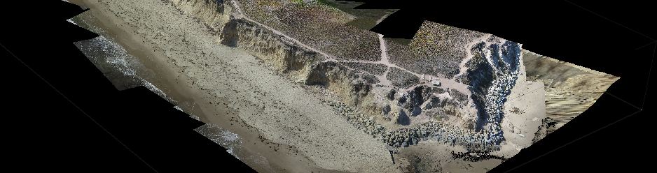
Based on work at the NSF Spatiotemporal Innovation Center in UC Santa Barbara, I developed a method for digitizing real-world landscapes as interactive 3D virtual environments. This method recreates the sights and sounds of a place, then allows users to navigate and interact with the environment as if they were actually in situ. Using only a kite, a camera, and a few easy-to-use software packages, anyone can record their experiences of a landscape and share them with others as easily as they might share an image or a video.
This project builds on the research of Kitty Currier, a PhD candidate in Geography at UC Santa Barbara. By using a kite to take aerial photographs and then processing those photographs with computer vision software, Kitty produced a low-cost, high-resolution 3D model of an Indonesian island. I have extended Kitty’s process by representing the 3D model within a video game engine and thoroughly documented my work flow so that it can be replicated by anyone, regardless of technical background.

Demo
You can download and test my recreation of Santa Barbara’s Campus Point cliffs here (warning: large file download). The full process is documented in a chapter of the book Geogames and Geoplay (Springer, 2018).
Downloading and opening the landscape is easy:
- Click on the link above to download the compressed game file
- Unzip the compressed file
- Open the folder and double-click on UC_Santa_Barbara_Cliffs.exe to view the landscape.
Navigating the Virtual Environment
Once the game is open, you will be able to explore the Campus Point cliffs at the University of California, Santa Barbara. Use the following controls to navigate:
- Move the mouse to look around
- Press the
W,A,S, andDkeys to move forwards, left, backwards, and right - Press the
QandEkeys to move upwards and downwards - Press
Alt + Tabto switch out of the window - Press
Alt + F4to close the window - For users with a VR headset, simply plug the headset into your computer on Extended Desktop mode to view the landscape in VR.
Want to know more? Please get in touch!